Post
by jadednihilist » Wed Jul 28, 2021 10:04 pm
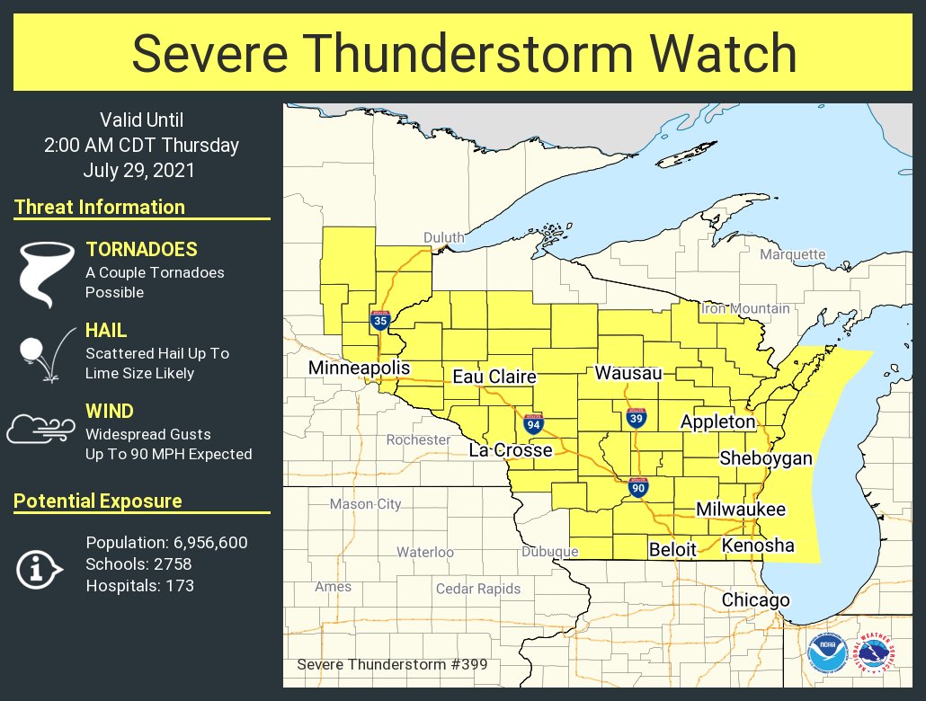
I got a chance to look at the 00Z upper level analysis. Of note is the extremely impressive sounding over Minneapolis with SBCAPE at 6060 J/kg(!!) with 37 kt 0-1 km shear, 45 kt 0-6 km shear, and a super elongated hodograph resulting in storm relative helicity values at 392 m^2/s^2 (!!) from 0-1 km and 480 m^2/s^2 at 0-3 km. This explains the supercells that are firing near the MN/WI border... these could quickly produce quite a nasty tornado.
Downstream in Green Bay, the instability (at 1177 J/kg with 236 J/kg CIN) remains modest and the wind profile has more modest (but still sufficient for organized convection) low level shear at 19 kts (0-1km) with 57 kt 0-6 km shear. As the low level jet pushes eastward, that will both serve to destabilize the atmosphere across central and eastern Wisconsin and also increase storm relative helicity.
At the 500 mb level, there's a developing weak shortwave trough extending from Duluth to south/east of Hudson Bay. This shortwave will increase the upper support for the mesolow that eventually forms from this developing derecho.
Michigan impacts
I agree with MW that now that we know where convective initiation is occurring, the severe threat is shifting westward, with a much lower chance of seeing extreme weather across Metro Detroit. The corridor of strongest winds will move across much of Wisconsin, perhaps into SW lower Michigan, and Illinois and Indiana. Heavy rain is still a distinct possibility here, as well as some isolated damaging wind gusts -- but overall shouldn't be too extreme.
This system will gradually move eastward into the mid Altantic tomorrow, increasing the severe weather threat down there.
I'm here for a good, hearty debate, to agree and disagree respectfully, and commiserate on the current state of terrestrial radio.