Some registered account users are experiencing password recognition issues. The issue appears to have been triggered by a PHP update last night. If this is occurring, please try logging in and using the "forgot password?" utility. Bear in mind auto-generated password reset emails may appear in your spam folder. If this does not work, please click the "Contact Us" option near the lower right hand corner of the index page to contact me via email.
Thank you for your patience!
- M.W.
Thank you for your patience!
- M.W.
Great Lakes Reception Maps
-
- Posts: 318
- Joined: Tue Sep 02, 2008 10:43 pm
- Location: Fremont, Mich. / Seoul, Korea
- Contact:
Great Lakes Reception Maps
As part of my coastal propagation project I've been working on for the past 18 years, I've been wrapping things up with maps and articles based upon my data. This particular map shows the average reception distance of all stations heard at any given site, including the 80 scenic beach sites I've done radio work at.
To calculate this, I use simply averages that anyone would learn in math class. Add up all the distances of every signal received at a site and then divide by the total number of stations received at that site. Easy peasy. In fact, even when a handful of distant signals are subtracted or added to the list or conditions and stations are quite different from one day to the next for those sites I have multiple bandscans for, it usually affects the overall average very little. At my home site in Muskegon, I took numerous scans over time and despite differing conditions, the average was 94 miles for one scan, 95, or 98 for exceptional conditions, while at other sites in the Thumb, doing multiple scans only changed the average two or three miles (fairly negligible), so one could assume that the averages are quite accurate, surprisingly even.
I'll continue to make some new maps based on these many bandscans from the past few years, such as station maps showing the signal levels of all the big stations (Lite 96.3, The Fox FM on 92.5 - now off-air - WPHN, all those monster signals that get out hundreds of miles). I'll be sure to post some of them here as I finish them because I know some of you radio dorks would love to see how your favorite station gets out (or in the case of 92.5, got out, since it's gone now - and that one got out almost all the way to Duluth).
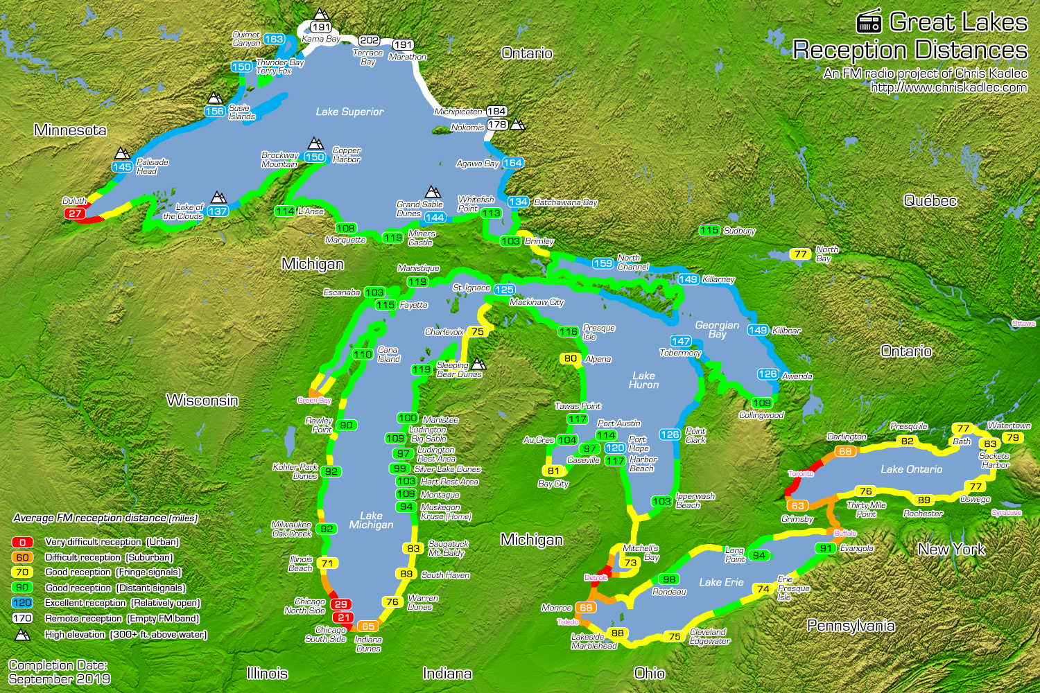
Click the above map to view the full-size version.
Marine propagation studies, Korean propaganda and jammers (8 hrs. of audio), 500+ Great Lakes TOH IDs (6 hrs.), Chinese AM TOH IDs (53 hrs.), Chinese and Taiwanese propaganda and jammers, plus articles and maps at www.chriskadlec.com • Tuner: Grundig G8 & TEF6686.
- audiophile
- Posts: 9236
- Joined: Sat Dec 04, 2004 9:21 pm
- Location: Between 88 and 108 MHz.
Re: Great Lakes Reception Maps
Radio Dork?
Ask not what your country can do FOR you; ask what they are about to do TO YOU!!
-
- Posts: 318
- Joined: Tue Sep 02, 2008 10:43 pm
- Location: Fremont, Mich. / Seoul, Korea
- Contact:
Re: Great Lakes Reception Maps
There seems to be a variety of different groups. There are those who reminisce all about what stations were decades ago, those who just love the radio business but don't care about the DXing side of things, those who care only about ratings and post them as if they really mattered (sorry, I still don't think they're accurate in a way to show who is really listening), and those who don't care about the radio business any whatsoever and only care about the DXing side of radio. I'm sure there are other groups. Either way, if we're here, we're a dork, geek, nerd - or in the radio business as an employer or employee - or whatever word you wish to use, because it seems the average person doesn't know or care much about radio. I'm a weird one because I am mostly into radio to study how it reacts with weather conditions. I suppose I'm a weather/radio hybrid of sorts.
Marine propagation studies, Korean propaganda and jammers (8 hrs. of audio), 500+ Great Lakes TOH IDs (6 hrs.), Chinese AM TOH IDs (53 hrs.), Chinese and Taiwanese propaganda and jammers, plus articles and maps at www.chriskadlec.com • Tuner: Grundig G8 & TEF6686.
Re: Great Lakes Reception Maps
I stated listening to FM radio in the EARLY '60s when there were big gaps in the band occupancy in Detroit. That's where I heard the DX ! I started with a 3 tube Tuner and high Z Xtal earphones (they actually were pretty HI-FI) I had a folded dipole made from 300 Ohm twinlead taped to the ceiling of my bedroom. Ran the feedline twinlead to the connection on the tuner where a 2 ft wire served as an antenna, soldered my leads on to there and chassis ground.
It Worked. I heard stations out to 300 miles at times. Sent for and received confirmation cards and letters from all over.
Today when I try to find an opening between local stations, all I find are "translators" and "Repeaters" rebroadcasting other, local FM station programming, Smile FM, and K love and a few Canadian stations that used to be on AM. NO Gaps for DX to get thru !
Last edited by k8jd on Tue Apr 14, 2020 2:47 pm, edited 1 time in total.
Re: Great Lakes Reception Maps
The stations I worked at in Chicago and here in Detroit would get reception reports, and even tapes of the signal we sent out, at times. The front office managment considered DX a waste of electricity since a lot of ads ($$revinue) were for local businesses. The Engineering cheif and staff would eventually get the items and would be excited at how well our signal reached out ! Two different worlds , we lived in !cckadlec wrote: ↑Tue Apr 14, 2020 10:06 amThere seems to be a variety of different groups. There are those who reminisce all about what stations were decades ago, those who just love the radio business but don't care about the DXing side of things, those who care only about ratings and post them as if they really mattered (sorry, I still don't think they're accurate in a way to show who is really listening), and those who don't care about the radio business any whatsoever and only care about the DXing side of radio. I'm sure there are other groups. Es.
Re: Great Lakes Reception Maps
I've for years been sending reception reports to AM and FM stations.
Not so often anymore. My most recent QSL from an AM was from April 30, 2015.
Re: Great Lakes Reception Maps
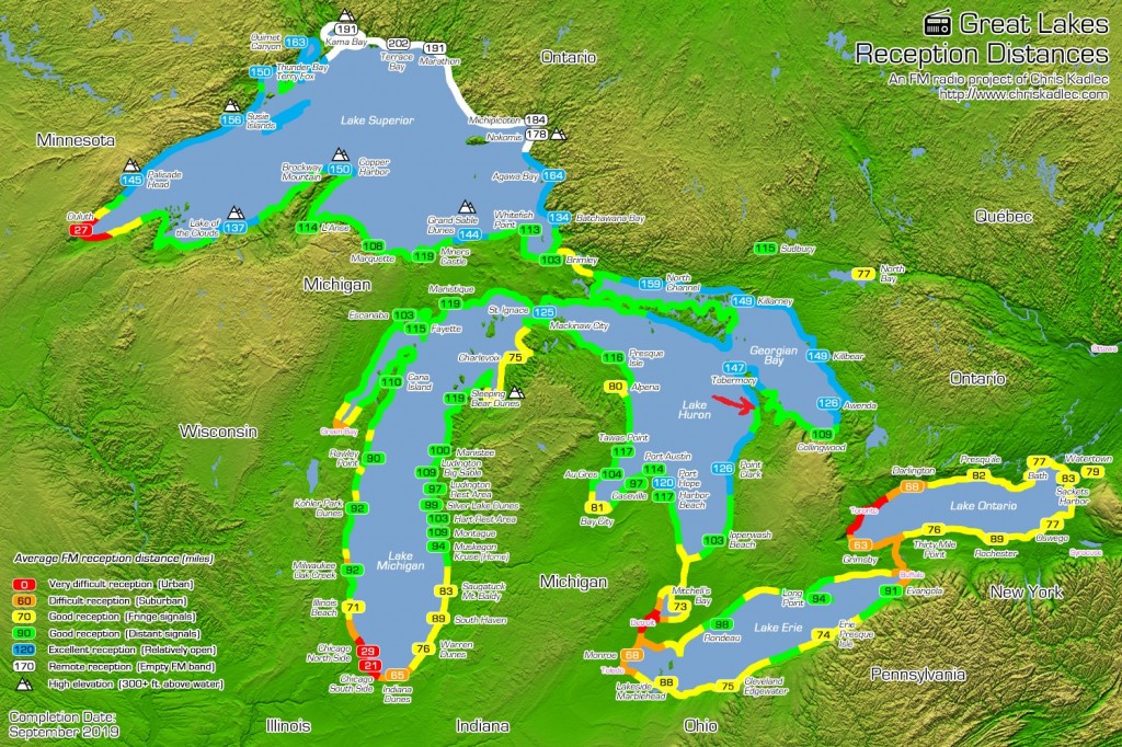
For a big part of my life I lived up on northern Lake Huron, where I've drawn the red arrow. Used to get pretty consistent FM from across the lake. Years ago there was no local FM at all up there. DX from Michigan was the only FM available. My most distant, verified reception was from Petoskey.
Re: Great Lakes Reception Maps
Well done!
I haven't seen FM DX data presented quite like this before. The map answers questions that I would never have thought to ask.
Back in my formative years, I was intensely interested in the correlation between TV DX conditions--especially on UHF--and severe weather. I had several interesting conversations with WFRV-TV meteorologists Tom Mahoney and Jeff Heaton on the subject.
Re: Great Lakes Reception Maps
The Chicago Milwaukee difference is probably because of the low 4-6 kW ERP of Chicago Area stations, except for WMBI-FM 90.1, WPWX 92.3, and WPPN 106.7. From what I've heard, Chicago is also mainly absent in jet airliners.
Also, once you get past N 43.5 and the grandfathered Western Michigan superpower facilities, you have a lot of Class C, Class C0, and Class C1 100 kW facilities.
When WLS-TV 7 and WTTW 11 were 316 kW ERP, they came in much better than the rest of the VHF stations with Lower ERP/Higher HAAT. Surprisingly WFLD 32 and WSNS 44 with 2500 kW ERP were quite weak, but as I recall they put a null to the East because they really didn't care much about Berrien County, and they could increase antenna gain toward the Chicago Area and reduce TPO. The Green Bay and Cadillac Traverse City VHFs were full power and on 2, 5, 7, 9, and 11, the same as Chicago.
Last edited by CK-722 on Fri Apr 17, 2020 6:49 pm, edited 4 times in total.
Is THAT where they got the idea for the 486-SX?
Same (x, y, z), different (t)
Your bullet missed my trial balloon.
RTN Price. Not guaranteed. As of 12:30, 157.71 Down 0.22.
Artificial Intelligence is a Child that needs a Parent to guide it through.
Same (x, y, z), different (t)
Your bullet missed my trial balloon.
RTN Price. Not guaranteed. As of 12:30, 157.71 Down 0.22.
Artificial Intelligence is a Child that needs a Parent to guide it through.
Re: Great Lakes Reception Maps
What you saw on camera was just a glimpse of an absolute class act: Tom's kindness, graciousness, and professionalism continue to inspire me to this day.MWmetalhead wrote: ↑Fri Apr 17, 2020 5:38 pm I remember Tom Mahoney! Watched him on TV while vacationing in the Esky/Gladstone area and also in Ludington. He was a terrific broadcaster. (I cannot comment on his forecast accuracy, since I only watched his work on a handful of occasions.)
He is now a deacon with the Diocese of Green Bay.
-
- Posts: 318
- Joined: Tue Sep 02, 2008 10:43 pm
- Location: Fremont, Mich. / Seoul, Korea
- Contact:
Re: Great Lakes Reception Maps
Thanks for the compliments on that. I always like hearing that I've given information someone never thought to ask. But I might actually have some upcoming maps that answer questions that people DO ask. I'll drop a load of about 20 maps most likely in the Northern Michigan category that show the signal reach of the top 20 stations in the Great Lakes. Most of them are from Northern Michigan since they can get over Lake Superior, Huron, and Michigan and beyond - WKLZ, WIAA, WPHN (goes all the way into Quebec regularly), WIAB, WKHQ, WLXT, etc. More than half the maps are done already. I'll link the post here when I post them.WC8KCY wrote: ↑Thu Apr 16, 2020 6:04 pm Well done!
I haven't seen FM DX data presented quite like this before. The map answers questions that I would never have thought to ask.
Back in my formative years, I was intensely interested in the correlation between TV DX conditions--especially on UHF--and severe weather. I had several interesting conversations with WFRV-TV meteorologists Tom Mahoney and Jeff Heaton on the subject.
Marine propagation studies, Korean propaganda and jammers (8 hrs. of audio), 500+ Great Lakes TOH IDs (6 hrs.), Chinese AM TOH IDs (53 hrs.), Chinese and Taiwanese propaganda and jammers, plus articles and maps at www.chriskadlec.com • Tuner: Grundig G8 & TEF6686.
Re: Great Lakes Reception Maps
WRVM has to be among the top 20, along with at least a couple Central UP stations (WGLQ, WYKX, WFXD, WIMK, and/or WCMM)cckadlec wrote: ↑Fri Apr 17, 2020 8:39 pmThanks for the compliments on that. I always like hearing that I've given information someone never thought to ask. But I might actually have some upcoming maps that answer questions that people DO ask. I'll drop a load of about 20 maps most likely in the Northern Michigan category that show the signal reach of the top 20 stations in the Great Lakes. Most of them are from Northern Michigan since they can get over Lake Superior, Huron, and Michigan and beyond - WKLZ, WIAA, WPHN (goes all the way into Quebec regularly), WIAB, WKHQ, WLXT, etc. More than half the maps are done already. I'll link the post here when I post them.WC8KCY wrote: ↑Thu Apr 16, 2020 6:04 pm Well done!
I haven't seen FM DX data presented quite like this before. The map answers questions that I would never have thought to ask.
Back in my formative years, I was intensely interested in the correlation between TV DX conditions--especially on UHF--and severe weather. I had several interesting conversations with WFRV-TV meteorologists Tom Mahoney and Jeff Heaton on the subject.
-
- Posts: 318
- Joined: Tue Sep 02, 2008 10:43 pm
- Location: Fremont, Mich. / Seoul, Korea
- Contact:
Re: Great Lakes Reception Maps
Of those, only WRVM would qualify. None of the other signals get out beyond Lake Michigan and a bit over Lake Superior, compared to the really big ones that span 3 lakes. GLQ has a decent signal; I'll have to see how far, but I don't suspect it went any further than Blind River to the east. All of those certainly go to the top of Lake Superior, but not far elsewhere. I'm still working on things, so we'll see. Just going up the frequencies on paper and jotting down the big ones and then checking to see their actual patterns to make sure they're as big as they are in my head.
Marine propagation studies, Korean propaganda and jammers (8 hrs. of audio), 500+ Great Lakes TOH IDs (6 hrs.), Chinese AM TOH IDs (53 hrs.), Chinese and Taiwanese propaganda and jammers, plus articles and maps at www.chriskadlec.com • Tuner: Grundig G8 & TEF6686.