Acceptable registrations in the queue through April 26 at 9:00p ET have now been activated. Enjoy! -M.W.
Terms of Use have been amended effective October 6, 2019. Make sure you are aware of the new rules! Please visit this thread for details:
https://www.mibuzzboard.com/phpBB3/view ... 16&t=48619
Discussion pertaining to Detroit, Ann Arbor, Port Huron, and SW Ontario
-
bmw
- Posts: 6847
- Joined: Sun Dec 05, 2004 1:02 am
Post
by bmw » Tue Apr 04, 2023 9:31 am
I'm not liking what I'm seeing today from the NWS severe weather outlook for tomorrow:
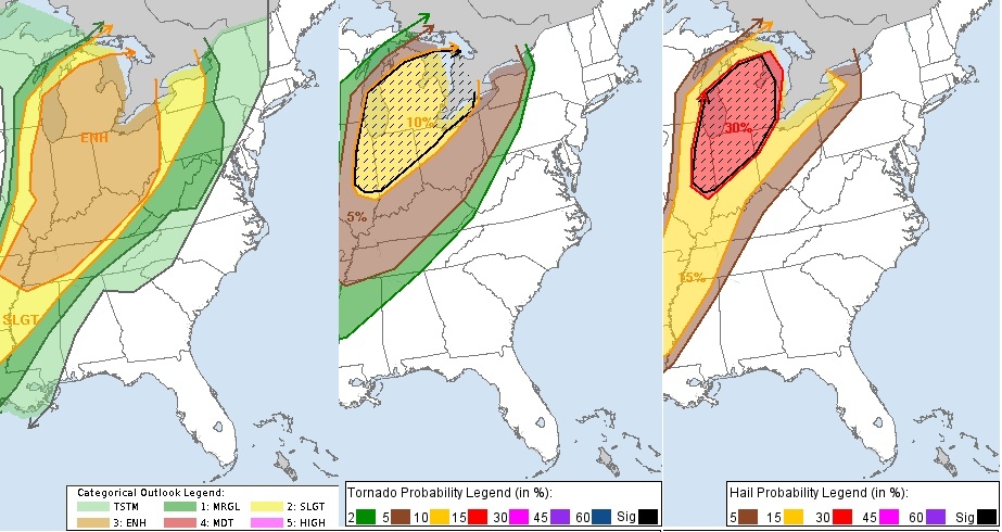
Given their definitions (10% chance of a tornado within 25 miles of any random point) and the size of the lower peninsula, it looks like at least several tornadoes somewhere in Michigan are a near certainty, and the black hatch marks suggest they could be powerful tornadoes. It also looks like massive hail stones are a near certainty in several places as well.
Technical discussion:
Scattered severe storms posing a risk for strong tornadoes and large
hail are expected in a corridor across eastern Illinois through
Lower Michigan Wednesday,
...This may commence in a pre-frontal corridor
as early as mid Wednesday morning across parts of central into
northeastern Illinois, before developing into/across Lower Michigan
and parts of adjacent northern Indiana and northwestern Ohio through
late afternoon.
It remains unclear what effect the cooler marine layer from Lake
Michigan has on adjacent coastal areas, particularly into portions
of western Michigan. However, Rapid Refresh forecast soundings, in
particular, indicate a rather potent thermodynamic and kinematic
environment supportive of strong tornadoes. This includes sizable
CAPE, strong deep-layer shear and large clockwise-curved low-level
hodographs.
https://www.spc.noaa.gov/products/outlook/day2otlk.html
-
Rate This
- Posts: 14130
- Joined: Wed Jan 08, 2020 12:17 am
Post
by Rate This » Tue Apr 04, 2023 10:12 am
bmw wrote: ↑Tue Apr 04, 2023 9:31 am
I'm not liking what I'm seeing today from the NWS severe weather outlook for tomorrow:
Given their definitions (10% chance of a tornado within 25 miles of any random point) and the size of the lower peninsula, it looks like at least several tornadoes somewhere in Michigan are a near certainty, and the black hatch marks suggest they could be powerful tornadoes. It also looks like massive hail stones are a near certainty in several places as well.
Technical discussion:
Scattered severe storms posing a risk for strong tornadoes and large
hail are expected in a corridor across eastern Illinois through
Lower Michigan Wednesday,
...This may commence in a pre-frontal corridor
as early as mid Wednesday morning across parts of central into
northeastern Illinois, before developing into/across Lower Michigan
and parts of adjacent northern Indiana and northwestern Ohio through
late afternoon.
It remains unclear what effect the cooler marine layer from Lake
Michigan has on adjacent coastal areas, particularly into portions
of western Michigan. However, Rapid Refresh forecast soundings, in
particular, indicate a rather potent thermodynamic and kinematic
environment supportive of strong tornadoes. This includes sizable
CAPE, strong deep-layer shear and large clockwise-curved low-level
hodographs.
https://www.spc.noaa.gov/products/outlook/day2otlk.html
There’s a slight risk from 8pm to 6am as well… hail and heavy rain with this part of it are the main threats… a bit early to be doing this.
-
Taco
- Posts: 606
- Joined: Sun Aug 21, 2022 9:55 am
Post
by Taco » Tue Apr 04, 2023 10:26 am
The Detroit stations will probably be sitting on their thumbs again. So sad...
Woe to you, oh earth and sea
For the Devil sends the beast with wrath
Because he knows the time is short
Let him who hath understanding reckon the number of the beast
For it is a human number
Its number is six hundred and sixty-six
-
MWmetalhead
- Site Admin
- Posts: 12052
- Joined: Sun Oct 31, 2004 11:23 am
Post
by MWmetalhead » Tue Apr 04, 2023 10:27 am
It's not (yet) a near certainty, but the risk of tornadoes, hail, damaging winds, and flash flooding are all in play for tomorrow.
Per the NWS forecast discussion from DTX, there are some factors in play that could limit mid-layer instability tomorrow, which could prevent surface based storms from tapping into the strong winds and cold air aloft.
I agree with the enhanced risk outlook at this time. Is there a chance it'll be upgraded to moderate come this time tomorrow? Sure.
In terms of tornadic risk, I think areas along and east of M-66 are at greatest risk.
Morgan Wallen is a piece of garbage.
-
Rate This
- Posts: 14130
- Joined: Wed Jan 08, 2020 12:17 am
Post
by Rate This » Tue Apr 04, 2023 11:45 am
NWS Detroit Hazardous Weather Outlook as of 856am this morning:
This hazardous weather outlook is for southeast Michigan.
.DAY ONE...Today and Tonight
There is a chance of thunderstorms tonight, with isolated severe
storms possible. The main threats will be localized heavy rainfall
and hail to 1 inch. Chances will be highest between 8pm and 6am and
storm motion will be southwest to northeast at 50 mph.
.DAYS TWO THROUGH SEVEN...Wednesday through Monday
A powerful low pressure system over the Upper Mississippi River
Valley will send a strong cold front through Southeast Michigan
Wednesday afternoon. A warm and humid air mass preceding the cold
front is expected to fuel numerous to widespread thunderstorm
development between Noon and 8 pm Wednesday. The potential exists
for significant severe weather development, including tornadoes and
hail greater than 1 inch, across all of Southeast Michigan.
.SPOTTER INFORMATION STATEMENT...
Spotter activation is not anticipated today and tonight.
-
Matt
- Posts: 9992
- Joined: Mon Dec 06, 2004 12:18 pm
- Location: Where Ben Zonia couldn't cut it
Post
by Matt » Tue Apr 04, 2023 2:04 pm
I'm currently in the Phoenix area for the week, and it was pretty windy yesterday, with winds closer to 30mph. Today is closer to 20. I wonder if this pattern is what is headed up to Michigan. Stay safe all.
Voting for Trump is dumber than playing Russian Roulette with fully loaded chambers.
-
Rate This
- Posts: 14130
- Joined: Wed Jan 08, 2020 12:17 am
Post
by Rate This » Tue Apr 04, 2023 2:23 pm
They’ve moved the Enhanced area west a bit but Michigan is still under the gun. Here is the latest SPC update blurb for us:
guidance.
...IL to OH and lower MI...
Confidence in the severe threat remains highest across portions of
the Midwest. Open warm sector convection may be ongoing by 12 UTC
across parts of eastern MO/IL and will propagate into parts of IN,
OH, and lower MI through the day. Poleward moisture advection in the
wake of morning convection will maintain a buoyant air mass prior to
the frontal passage in the late morning/afternoon when a second
round of storms appears likely. The combination of the mid-level jet
max aloft and strong low-level pressure gradient winds will result
in a strongly sheared environment featuring effective bulk shear
values near 50s knots and 150-200 m2/s2 of 0-1 km SRH. This
kinematic environment will support a tornado threat, including the
potential for a strong tornado, especially if more discrete storm
modes can be realized (though it is unclear if boundary-relative
storm motions and deep-layer shear vectors will be sufficient to
maintain discrete modes given considerable along-boundary mean
flow). Regardless, the strong low-level flow will support the
potential for damaging to severe winds.
It doesn’t sound as bullish as before on Tornadoes.
-
MWmetalhead
- Site Admin
- Posts: 12052
- Joined: Sun Oct 31, 2004 11:23 am
Post
by MWmetalhead » Tue Apr 04, 2023 3:27 pm
Agreed. I'm thinking any upgrade to moderate risk won't occur until the extent of debris cloud cover from tomorrow morning's action is known.
Morgan Wallen is a piece of garbage.
-
Mega Hertz
- Posts: 4266
- Joined: Fri Jun 15, 2012 10:09 pm
- Location: Brighton
Post
by Mega Hertz » Tue Apr 04, 2023 4:01 pm
Better get the generator ready

"Internet is no more like radio than intravenous feeding is like fine dining."
-TurkeyTop
-
Realist
- Posts: 996
- Joined: Wed Dec 13, 2006 10:36 pm
- Location: Northern Michigan
Post
by Realist » Tue Apr 04, 2023 7:43 pm
-
Rate This
- Posts: 14130
- Joined: Wed Jan 08, 2020 12:17 am
Post
by Rate This » Wed Apr 05, 2023 5:49 am
The latest Hazardous Weather Outlook from NWS Detroit:
A powerful low pressure system will lift into the western Great Lakes
bringing a warm and humid air mass preceding a cold front. This will fuel
numerous to widespread thunderstorm late this morning through the
early afternoon. The potential exists for significant severe weather
development, including tornadoes and hail greater than 1 inch, and
damaging winds across all of Southeast Michigan. Numerous clusters of
storms will be moving southwest to northeast at around 50-60 mph with
the main window for severe weather between 11 am to 4 pm.
The SPC outlook for day 1 now has the area of concern west of us which I imagine will change as it seems to be focused on last night. All the warnings I saw last night appeared to be garden variety severe storms.
-
MWmetalhead
- Site Admin
- Posts: 12052
- Joined: Sun Oct 31, 2004 11:23 am
Post
by MWmetalhead » Wed Apr 05, 2023 6:10 am
Northern MI has been downgraded to slight risk for today.
Enhanced Risk is basically from M-20 southward now.
Much of OH and virtually all of IN have been upgraded to Enhanced Risk.
Best threat for SVR is from 11a to 4p today. I do think the strong tornado threat is limited; not as bullish as yesterday. Best chance for a tornado is across the thumb, the I-69 corridor, SE Michigan, northern IN, and NW Ohio.
I think the predominant mode of storms could prove to be a fast moving squall line in the early to mid afternoon hours that produces 60 to 70 mph gusts and hail up to quarter size. Ahead of that line some scattered discrete cells could percolate, which is where the tornado threat and hail to golfball size threat will be greatest.
The surface warm front won't make it as far north as forecast yesterday. The storm activity overnight and this morning will be an inhibiting factor. I think it will stall across central Michigan; I think areas north of, say, Saginaw will only get into the warm sector for a few hours at most today before the cold front plows through. I think St. Clair County could be another area where that same outcome happens.
Coldwater is already 69 degrees. Jackson is only at 54. The boundary extends from about Muskegon to Hillsdale right now. Holland is reporting 67.
Severe storms are already forming in the Benton Harbor and Dowagiac areas, and movement is to the NNE. There is an impressive amount of lightning with that activity.
Models right now are showing a BIG TIME warm up for next week. Easter Sunday should be very pleasant with temps about 5 to 7 degrees above average in SE Michigan, but it will be downright warm beginning Tuesday or Wednesday if model projections come true.
Morgan Wallen is a piece of garbage.
-
Rate This
- Posts: 14130
- Joined: Wed Jan 08, 2020 12:17 am
Post
by Rate This » Wed Apr 05, 2023 7:35 am
MWmetalhead wrote: ↑Wed Apr 05, 2023 6:10 am
Northern MI has been downgraded to slight risk for today.
Enhanced Risk is basically from M-20 southward now.
Much of OH and virtually all of IN have been upgraded to Enhanced Risk.
Best threat for SVR is from 11a to 4p today. I do think the strong tornado threat is limited; not as bullish as yesterday. Best chance for a tornado is across the thumb, the I-69 corridor, SE Michigan, northern IN, and NW Ohio.
I think the predominant mode of storms could prove to be a fast moving squall line in the early to mid afternoon hours that produces 60 to 70 mph gusts and hail up to quarter size. Ahead of that line some scattered discrete cells could percolate, which is where the tornado threat and hail to golfball size threat will be greatest.
The surface warm front won't make it as far north as forecast yesterday. The storm activity overnight and this morning will be an inhibiting factor. I think it will stall across central Michigan; I think areas north of, say, Saginaw will only get into the warm sector for a few hours at most today before the cold front plows through. I think St. Clair County could be another area where that same outcome happens.
Coldwater is already 69 degrees. Jackson is only at 54. The boundary extends from about Muskegon to Hillsdale right now. Holland is reporting 67.
Severe storms are already forming in the Benton Harbor and Dowagiac areas, and movement is to the NNE. There is an impressive amount of lightning with that activity.
Models right now are showing a BIG TIME warm up for next week. Easter Sunday should be very pleasant with temps about 5 to 7 degrees above average in SE Michigan, but it will be downright warm beginning Tuesday or Wednesday if model projections come true.
The squall line in Illinois has 3 tornado warnings with it right now… this is more activity than we had last night out there. Toledo went from 56-71 in an hour (!)…
-
MWmetalhead
- Site Admin
- Posts: 12052
- Joined: Sun Oct 31, 2004 11:23 am
Post
by MWmetalhead » Wed Apr 05, 2023 7:48 am
Whoa! You're right. Toledo was only in the mid 50s when I checked an hour ago.
Adrian is still only 57.
Lake Erie is probably f*cking with the warm front, as is common this time of year.
Morgan Wallen is a piece of garbage.
-
Rate This
- Posts: 14130
- Joined: Wed Jan 08, 2020 12:17 am
Post
by Rate This » Wed Apr 05, 2023 7:53 am
MWmetalhead wrote: ↑Wed Apr 05, 2023 7:48 am
Whoa! You're right. Toledo was only in the mid 50s when I checked an hour ago.
Adrian is still only 57.
Lake Erie is probably f*cking with the warm front, as is common this time of year.
I think you’re right because when I heard the 56 number I heard Chicago at 70 and Cleveland at 71 on the same report on the weather radio… given they are basically in a straight line from each other it has to be the lake unless the front is shaped strangely.
I see 75 and mostly sunny for Tuesday. This may be an active severe weather season if we keep going up that high and crashing back to earth. Maybe this is related to the switch between El Niño and La Niña or vice versa (I can’t remember off hand which it was).
Interestingly the Palm Sunday 1965 Tornado outbreak occurred April 10-12 so it’s not unprecedented to be doing this now… just uncommon. That one produced 55 tornados in 40 hours.
The period 1950-1975 produced a lot of tornados around here with several of them major ones… maybe we are drifting back into that kind of pattern.
Last edited by
Rate This on Wed Apr 05, 2023 7:56 am, edited 1 time in total.