I've seen varied forecasts from our various media outlets, AccuWeather, and from the National Weather Service.
Some call for only 2 to 4 inches of storm total snow along the border counties, and in 1 instance, as far north as 8 Mile Rd.
For the brunt of Oakland County, the bandwidth seems to range from 3 to 5 inches on the low end (Fox 2 and The Weather Channel) to 6 to 10 inches on the high end (AccuWeather). I believe I saw 5 to 8 inches on channel 4; the NWS in its official warning product is calling for a range of 3 to 7 for Oakland.
Of note, the AccuWeather forecast of 6 to 10 inches also applies to all of Wayne County and the city of Detroit, so they are an outlier in that regard.
Just about everyone seems to agree that areas along and behind a line from Howell to Lapeer will see higher totals, with totals becoming progressively higher as one heads closer & closer to western, central and northern lower Michigan.
Additionally, just about everyone seems to agree on the longevity and strength of the strong wind gusts that are forecast (widespread 50 mph gusts, possibly higher, from midday Friday through Friday night) and strength of the arctic air that will settle into our region beginning Friday. 40 mph gusts could still occur into Saturday afternoon, especially east side and thumb.
My prediction for snowfall:
- I think some of the in-house HRRR models used by local TV outlets are too aggressive on keeping rainfall around into the evening. I think almost all areas, if precip is falling, will see snow by 7PM. An exception might be shoreline areas of Monroe, Wayne, Macomb and St. Clair counties. For areas along & west of US 23 and along & north of I-94, I think nearly all precip from this event will be snow. There could be a period of a wintry mix or a rain / snow mix in that same region.
- I think snowfall banding will be tilted in more of a NE to SW orientation.
- My prediction is for 7 to 10 inches of snow across western Washtenaw, much of Livingston, and Genesee counties back toward Jackson, Lansing, Midland, and Saginaw.
- From Ann Arbor, western Wayne, through most of Oakland County, northwestern Macomb County and into Lapeer County, I am predicting 5 to 8 inches.
- For western Monroe, eastern Wayne, most of Macomb County and most of St. Clair County, I am predicting 4 to 6 inches.
- For downriver areas of Wayne County near the water and for eastern Monroe County and Toledo, I am predicting 2 to 5 inches.
Wind gusts:
- Travel could still be dangerous even in the areas that see the least amount of snow.
- Most areas will see multiple gusts in excess of 50 mph.
- Areas closest to the water will likely see at least one gust to 60 mph.
- A couple isolated gusts to 70 mph are not out of the question, especially north of Port Huron along the Lake Huron shoreline.
- Worst winds will occur from early Friday afternoon until around / shortly after sunrise Saturday morning.
Will we have true "blizzard" conditions at any point in the region? That is debatable. While the models are showing very high wind gusts, most are keeping sustained winds around 25 mph. For a blizzard to occur, sustained winds (not gusts) must be at least 35 mph, visibility must be 1/4 mile or less, and snow must be falling for at least three hours consecutively.
Biggest concern by far is the power outage risk as an arctic airmass settles overhead.
DTE supposedly has 700 line workers ready to be dispatched. Frankly, I think that number is too low.
Acceptable registrations in the queue through April 26 at 9:00p ET have now been activated. Enjoy! -M.W.
Terms of Use have been amended effective October 6, 2019. Make sure you are aware of the new rules! Please visit this thread for details: https://www.mibuzzboard.com/phpBB3/view ... 16&t=48619
Terms of Use have been amended effective October 6, 2019. Make sure you are aware of the new rules! Please visit this thread for details: https://www.mibuzzboard.com/phpBB3/view ... 16&t=48619
Thu. night - Saturday storm system
-
MWmetalhead

- Site Admin
- Posts: 12059
- Joined: Sun Oct 31, 2004 11:23 am
Re: Thu. night - Saturday storm system
Three things that we will all get is a flash freeze, dangerous windchills, and damaging wind gusts. Both sides of the border have a Winter Storm Warning.
https://weather.gc.ca/city/pages/on-94_metric_e.html
https://weather.gc.ca/city/pages/on-147_metric_e.html
https://www.getprepared.gc.ca/cnt/kts/index-en.aspx
https://www.wunderground.com/
https://weather.gc.ca/city/pages/on-94_metric_e.html
https://weather.gc.ca/city/pages/on-147_metric_e.html
https://www.getprepared.gc.ca/cnt/kts/index-en.aspx
https://www.wunderground.com/
Re: Thu. night - Saturday storm system
The forecasts for this storm have varied so much depending on the day and the source. A few days ago, both The Weather Channel and the GFS were saying mostly rain up here where I'm at on the Lake Huron shoreline. Most models though have pushed that rain line further east out over the lake other than maybe some brief rain/mixing at the very start of the event.
I think the GFS model has a pretty good handle on snowfall totals.
I think the GFS model has a pretty good handle on snowfall totals.
-
MWmetalhead
- Site Admin
- Posts: 12059
- Joined: Sun Oct 31, 2004 11:23 am
Re: Thu. night - Saturday storm system
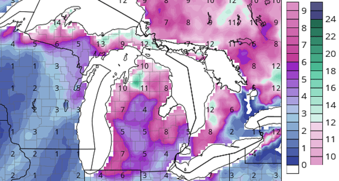
What is the timeframe for those snow accumulations? The numbers in central and especially western lower Michigan look too low.
Morgan Wallen is a piece of garbage.
Re: Thu. night - Saturday storm system
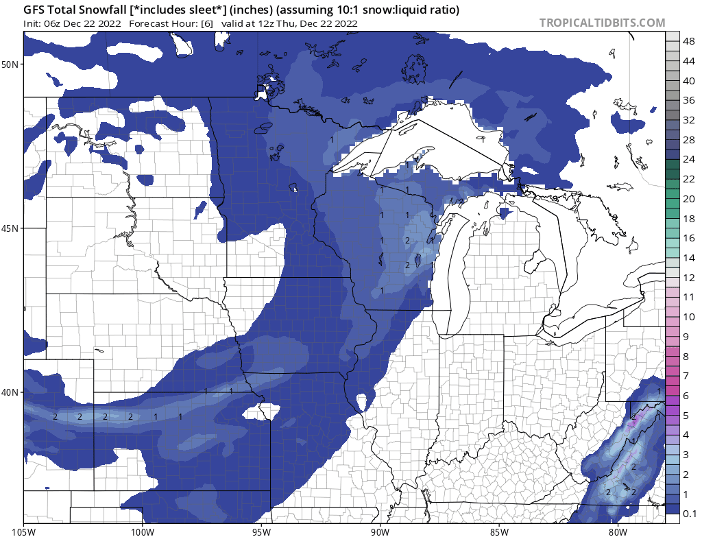
Subtract 4 hours from each of the time stamps on the image for EDT.
-
MWmetalhead
- Site Admin
- Posts: 12059
- Joined: Sun Oct 31, 2004 11:23 am
Re: Thu. night - Saturday storm system
I think those projections are in the ballpark for northern lower and the thumb but too low for some of southern and for much of western lower.
The 5 inch projected storm total for GRR is way too low, for example.
By the way, looks like the DTX radar site is down. Great timing. Update - it supposedly will be back online by Noon today. It is down temporarily for scheduled maintenance.
The 5 inch projected storm total for GRR is way too low, for example.
By the way, looks like the DTX radar site is down. Great timing. Update - it supposedly will be back online by Noon today. It is down temporarily for scheduled maintenance.
Morgan Wallen is a piece of garbage.
-
MWmetalhead
- Site Admin
- Posts: 12059
- Joined: Sun Oct 31, 2004 11:23 am
Re: Thu. night - Saturday storm system
WZZM is forecasting widespread 15+ inch totals for areas along and west of 131 when combining synoptic snow with lake effect this weekend.
Morgan Wallen is a piece of garbage.
Re: Thu. night - Saturday storm system
If I'm reading that map right, I think Grand Rapids is just inside the 7-9 inch band.
The reason the models are suggesting lower totals right in the middle of the state (Ionia, St. John's, Mt. Pleasant, and surrounding areas) is because the main snow band is setting up as the low moves from SW to NE along basically I-75 and east. West of that line will get less snow from the main band but the snow belts will get lingering lake effect. That leaves the blob just west of I-75 but east of the main snow belts in the southern half of the state getting less snow from the main band and missing out on much of the lake effect. I think there will be a small area right in the middle of the state that stays in the 4-6 inch range.
The reason the models are suggesting lower totals right in the middle of the state (Ionia, St. John's, Mt. Pleasant, and surrounding areas) is because the main snow band is setting up as the low moves from SW to NE along basically I-75 and east. West of that line will get less snow from the main band but the snow belts will get lingering lake effect. That leaves the blob just west of I-75 but east of the main snow belts in the southern half of the state getting less snow from the main band and missing out on much of the lake effect. I think there will be a small area right in the middle of the state that stays in the 4-6 inch range.
-
MWmetalhead
- Site Admin
- Posts: 12059
- Joined: Sun Oct 31, 2004 11:23 am
Re: Thu. night - Saturday storm system
I did see the low pressure center movement is now going to be a bit faster than what was predicted 24 hours ago, when model runs were forecasting it to linger over central or eastern Lake Huron in nearly stationary fashion for several hours.
Morgan Wallen is a piece of garbage.

Re: Thu. night - Saturday storm system
Looking at 12-24 in Traverse City with gusts to 55mph. Blizzard Warning... Fun times...
“The more you can increase fear of drugs, crime, welfare mothers, immigrants and aliens, the more you control all of the people.”
― Noam Chomsky
Posting Content © 2024 TC Talks Holdings LP.
― Noam Chomsky
Posting Content © 2024 TC Talks Holdings LP.
-
craig11152

- Posts: 2049
- Joined: Tue Nov 06, 2007 8:15 am
- Location: Ann Arbor
Re: Thu. night - Saturday storm system
The NOAA and the Weather Underground are both looking at 2-4 inches in Ann Arbor. That is what I am believing. They both just plain predict the weather. The media outlets seem to "pump" the weather whenever possible.
I no longer directly engage trolls
-
MWmetalhead
- Site Admin
- Posts: 12059
- Joined: Sun Oct 31, 2004 11:23 am
Re: Thu. night - Saturday storm system
Fox 2 agrees with those predictions more or less. I do not.
We shall see who is right. 🥸
We shall see who is right. 🥸
Morgan Wallen is a piece of garbage.
-
MWmetalhead
- Site Admin
- Posts: 12059
- Joined: Sun Oct 31, 2004 11:23 am
Re: Thu. night - Saturday storm system
WOOD-TV in Grand Rapids is predicting storm total snowfall values in line with those of WZZM.
WOOD-TV is calling this "the worst storm in many years" for its viewing area. That is a remarkable statement considering many highly populated areas of West Michigan received 18 to 24 inches of snow over 2 to 3 days just ~40 days ago!
https://www.woodtv.com/weather/forecast ... -forecast/
A band of intensifying snowfall is developing from South Haven, to Grand Rapids, to Greenville as we speak.
Morgan Wallen is a piece of garbage.
Re: Thu. night - Saturday storm system
Storm continues to speed up and the computer models continue to expand the area that may only get 3 or 4 inches. Pretty much the entire southern half of the lower peninsula, excluding parts of the thumb and the southwest part of the state.
